![]()
![]()
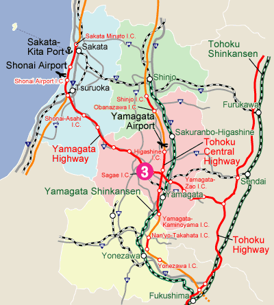
| The outline of Industrial Park | |
|---|---|
| Location | Sagae City |
| Developer | Sagae City Land Development Public Corporation |
| Total Area | 174.2ha |
| Possible sale area | 12.9ha |
| Selling price (yen/m2) | 14,500 |
| Highway |
Yamagata Expressway
Sagae Smart I.C.(2km 3min.) |
| National road | Route112 Close(1min.) |
| Airport | Yamagata Airport(14km, 15min.) |
| Port | Sakata North Port (95km, 90min.) |
| Railroad |
Yamagata Shinkansen
Yamagata Station(19km, 20min.) |
| The present condition | Prepared(4.7ha) Order-made (The rest) |
| Area to be used | Industrial special area,Industrial area |
| Building code etc. | Building coverage/60% Floor area ratio/200% N value/More than 50 |
| Water | Water supply/600m3/day Industrial water/- Ground water/Available |
| Drainage | To be processed by the corporate independently, and then drained to Numagawa River(The extension site is the public drain.) |
| Electricity | 1㎞ from Sagae Transformer Substation |
| Communication | Optical line is available |
| Regulation | Noise regulation/No Vibration regulation/No |
| Green Standards | Green coverage/More than5% Rate of environmental facilities/More than10% |
| Lease plan | No |
| The outline of Location | |
|---|---|
| Region | Murayama Region |
| Population | about 541,000 |
| School | Yamagata University (Faculty of Literature and Social Science, Faculty of Education, Faculty of Science, Faculty of Medicine) |
| Tohoku University of Art & Design | |
| Yamagata College of Industry and Technology | |
| 25 High schools | |
| URL | Sagae City |