![]()
![]()
| The outline of Industrial Park | |
|---|---|
| Location | Sakata City |
| Developer | Yamagata Pref. |
| Total Area | 345.1ha |
| Possible sale area | 12.5ha |
| Selling price (yen/m2) | 14,900 |
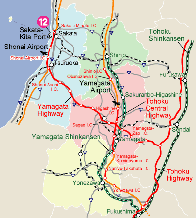
| Highway |
Nihonkai-Tohoku Expressway
Sakata Minato I.C.(2 km, 3min.) |
| National road | Adjacent Route 7(0min.) |
| Airport | Shonai Airport(23km, 20min.) |
| Port | close to Sakata-Kita Port(0min.) |
| Railroad | Sakata Station(6km, 10min.) |
| The present condition | Prepared (One part roughly prepared) |
| Area to be used | Industrial special area, Industrial area,To be industrial area |
| Building code etc | Building coverage/60% Floor area ratio/200% N value/24~31 |
| Water | Water supply/122m3/day Industrial water/22,000㎡/day Ground water/unavailable |
| Drainage | To be processed by each corporate |
| Electricity | Sakata Kita KouTransformer Substation (135,000KVA) (In Industrial Park) |
| Communication | Optical line is available |
| Regulation | Noise regulation/No Vibration regulation/No |
| Green Standards | Green coverage/More than 5~10% Rate of environmental facilities/More than 10~15% |
| Lease plan | Price/1.4%of selling price(about17yen/㎡ per month) Lease term/For 10 years(Purchase conditions after 10 years included) Deposit/10% of selling price, return when expired, without interest |
| The outline of Location | |
|---|---|
| Region | Shonai Region |
| Population | about 271,000 |
| School | Yamagata University (Faculty of Agriculture) |
| Tohoku University of Community Service and Science | |
| Tsuruoka National College of Technology | |
| 16 High schools | |
| URL | Sakata City |