![]()
![]()
| The outline of Industrial Park | |
|---|---|
| Location | Tsuruoka City |
| Developer | Tsuruoka City Land Development Public Corporation |
| Total Area | 28.5ha |
| Possible sale area | 10.2ha |
| Selling price (yen/m2) | 15,800~ |
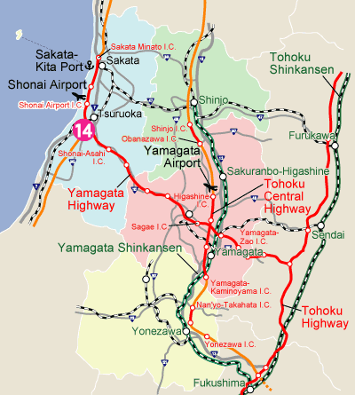
| Highway |
Yamagata Highway
Tsuruoka I.C.(3km, 5min.) |
| National road | Route 7(2km, 3min.) |
| Airport | Shonai Airport(10km, 15min) |
| Port | Sakata-Kita Port(34km, 25min) |
| Railroad | Tsuruoka Station(7km, 10min) |
| The present condition | Prepared |
| Area to be used | Industrial area |
| Building code etc. | Building coverage/60% Floor area ratio/200% N value/20~50 |
| Water | Water supply/51,000m3/day Industrial water/- Ground water/- |
| Drainage | To be processed by the corporate and then drained to the public drain |
| Electricity | Ooyama Transformer Substation(35,000kVA) (adjacent) |
| Gas | Propane gas |
| Communication | Optical line is available |
| Regulation | Noise regulation/No Vibration regulation/No |
| Green Standards | Rate of environmental facilities/More than10% |
| Lease plan | Price/Selling price/Long range plan(Variable interest rate)+Tax equivalent assets ×2 Lease term/to be renewed within 20 years max. |
| The outline of Location | |
|---|---|
| Region | Shonai Region |
| Population | about 271,000 |
| School | Yamagata University (Faculty of Agriculture) |
| Tohoku University of Community Service and Science | |
| Tsuruoka National College of Technology | |
| 16 High schools | |
| URL | Tsuruoka City |